Here is the introduction with the vocabulary:
https://www.smore.com/k858t-children-on-the-move
Here is the article with the questions:
http://teachunicef.org/sites/default/files/gcb-magazine-lesson-plans/Children_On_The_Move_Ambassador_0.pdf
Here are the follow up questions:
One Boy’s Life on the Move (page 4)
How would you react if Mustapha’s story were yours? What challenges might you face adjusting to life in a new country? What would you miss most? What would you hope to get from your new country?
Closer to Home: Child Migrants from Latin America (page 7)
Should the United States take in children and families facing harm at home—or should we tighten our borders while we deal with threats from abroad and economic uncertainty at home?
What can you do in your personal life and in your larger
community to welcome and support immigrants and other
newcomers?
Friday, February 24, 2017

Wednesday, February 15, 2017


Friday, February 10, 2017


Wednesday, February 1, 2017
Europe Study Guide
Part 1 of the study guide (you must be logged into the cloud):
https://drive.google.com/open?id=0B1MUdxetj8MAdzU4WjEtME9qMVE
Part 2:
https://drive.google.com/open?id=0B1MUdxetj8MAdzU4WjEtME9qMVE
Part 2:
Why didn’t
Hitler invade Switzerland?
Which
mountains separate Spain from France?
Which
mountains are in France, Austria, Germany, Italy, and Switzerland?
When did the
Spanish Inquisition occur?
What did the
Spanish dictator Franco do to discourage Hitler from invading?
Spain,
Portugal, Italy and France are predominantly which religion?
What is the
Industrial region in Germany and France?
Which
countries were taken over by Hitler without a fight
List some
examples of British colonies.
Which
country was part of Hitler’s plan to move into Africa?
Written Prompt:
How did the physical landscape of Europe influence the course of the war?
How did the physical landscape of Europe influence the course of the war?
Tuesday, January 3, 2017
Europe Mapping Lab
Europe Mapping Lab
Use the attached instructions and the maps on 262-266 to create a sketch map of Europe. Scans of the physical and political maps are at the end of the post. To zoom in on any of the attachments- right click, then choose "open link in new tab" and you will be able to zoom in on the image.


The attached images have questions that relate to the maps on pages 262-266. Along with your answer for each question, also write down the map or maps you used.
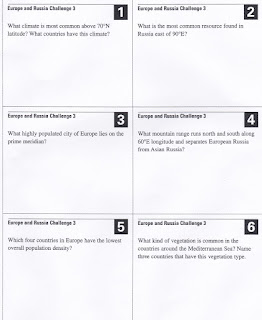


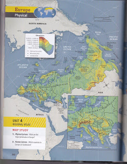


The attached images have questions that relate to the maps on pages 262-266. Along with your answer for each question, also write down the map or maps you used.


Tuesday, November 29, 2016
East Asia Sketch Map Questions
East Asia Sketch Map Questions:
1. Where do you think population is most dense? Give at least two factors to support your prediction.
2. Where do you think population is least dense? Give at least two factors to support your prediction.
3. Why is water such an important resource?
4. What factors would explain why there is so much agriculture?
5. Which factors best explain why population is so sparse in the North and West?
6. Which industries would you expect to grow the most? Why?

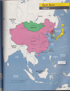


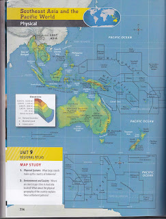

1. Where do you think population is most dense? Give at least two factors to support your prediction.
2. Where do you think population is least dense? Give at least two factors to support your prediction.
3. Why is water such an important resource?
4. What factors would explain why there is so much agriculture?
5. Which factors best explain why population is so sparse in the North and West?
6. Which industries would you expect to grow the most? Why?


Religious Tolerance In SE Asia
Today's task is to investigate religious tolerance in SE Asia.
1. Log into the cloud and open Google Apps For Students
2. Use the following link to access the articles, maps, and data to help you respond to the "Student Response Organizer." There is also a chart to remind you of the different religions in the region.
https://drive.google.com/open?id=0B1MUdxetj8MAb1NDZ3dwbWJQWDQ
3. When finished, complete the "FINAL ASSESSMENT."
1. Log into the cloud and open Google Apps For Students
2. Use the following link to access the articles, maps, and data to help you respond to the "Student Response Organizer." There is also a chart to remind you of the different religions in the region.
https://drive.google.com/open?id=0B1MUdxetj8MAb1NDZ3dwbWJQWDQ
3. When finished, complete the "FINAL ASSESSMENT."
Subscribe to:
Posts (Atom)